Konnevesi
Konnevesi | |
|---|---|
Municipality | |
| Konneveden kunta Konnevesi kommun | |
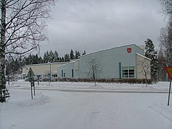
 The municipal house of Konnevesi | |
 Location of Konnevesi in Finland | |
| Coordinates: 62°37.7′N 026°17′E / 62.6283°N 26.283°E | |
| Country | |
| Region | Central Finland |
| Sub-region | Äänekoski |
| Charter | 1922 |
| Government | |
| • Municipal manager | Kari Levänen |
| Area (2018-01-01)[1] | |
• Total | 680.85 km2 (262.88 sq mi) |
| • Land | 512.94 km2 (198.05 sq mi) |
| • Water | 167.95 km2 (64.85 sq mi) |
| • Rank | 171st largest in Finland |
| Population (2024-10-31)[2] | |
• Total | 2,458 |
| • Rank | 236th largest in Finland |
| • Density | 4.79/km2 (12.4/sq mi) |
| Population by native language | |
| • Finnish | 97.9% (official) |
| • Others | 2.1% |
| Population by age | |
| • 0 to 14 | 12.6% |
| • 15 to 64 | 53.1% |
| • 65 or older | 34.2% |
| Time zone | UTC+02:00 (EET) |
| • Summer (DST) | UTC+03:00 (EEST) |
| Website | www.konnevesi.fi |
Konnevesi is a municipality of Finland. It is located in the former province of Western Finland and is part of the Central Finland region. The municipality has a population of 2,458 (31 October 2024)[2] and covers an area of 680.85 square kilometres (262.88 sq mi) of which 167.95 km2 (64.85 sq mi), or almost 25%, is water.[1] Neighbouring municipalities are Hankasalmi, Laukaa, Rautalampi, Vesanto and Äänekoski. The municipality is unilingually Finnish.
There are altogether exactly 100 lakes in Konnevesi. The biggest lakes are Keitele, Lake Konnevesi and Liesvesi.[5] The population density is 4.79 inhabitants per square kilometre (12.4/sq mi).
The logging tongs appearing in Konnevesi's coat of arms refer to local forestry. The coat of arms was designed by Gustaf von Numers, and the Konnevesi municipal council approved it in its meetings on 23 April 1964. The Ministry of the Interior approved the coat of arms for use on 21 August that year.[6][7]
History
[edit]The toponym Konnevesi was first mentioned in 1554 as Konnevessij äremarch. The name is derived from the lake Konnevesi, which in turn likely refers to a Sámic word meaning "deer" (reconstructed proto-Sámic *kontē).[8]
Konnevesi was separated from Rautalampi in 1922.[8] A municipal merger with Laukaa was planned in 2012, but was not accepted by the municipal government of Konnevesi.[9]
Villages
[edit]
|
|
|
Dialect
[edit]The dialect of Konnevesi is a Savonian dialect. The dialect is transitional between the Central Finnish and Northern Savonian subgroups, with the speech of the western villages having more Central Finnish features while the speech in the eastern villages (such as Mäkäräniemi) is closer to the Northern Savonian dialects.[12]
Notable individuals
[edit]- Juha Karjalainen, former soccer player[citation needed]
- Miika Lahti, ice hockey player[citation needed]
Gallery
[edit]-
Konnevesi Church
-
A windmill at Konnevesi Museum
-
Lake Keitele in Konnevesi
-
Siikakoski rapid
-
Neituri canal
See also
[edit]References
[edit]- ^ a b "Area of Finnish Municipalities 1.1.2018" (PDF). National Land Survey of Finland. Retrieved 30 January 2018.
- ^ a b c "Finland's preliminary population figure was 5,635,560 at the end of October 2024". Population structure. Statistics Finland. 19 November 2024. ISSN 1797-5395. Retrieved 22 November 2024.
- ^ "Population according to age (1-year) and sex by area and the regional division of each statistical reference year, 2003–2020". StatFin. Statistics Finland. Retrieved 2 May 2021.
- ^ a b "Luettelo kuntien ja seurakuntien tuloveroprosenteista vuonna 2023". Tax Administration of Finland. 14 November 2022. Retrieved 7 May 2023.
- ^ "Konnevesi". Järviwiki. Finland's Environmental Administration. 2012. Retrieved 27 February 2012.
- ^ Suomen kunnallisvaakunat (in Finnish). Suomen Kunnallisliitto. 1982. p. 141. ISBN 951-773-085-3.
- ^ "Sisäasiainministeriön vahvistamat kaupunkien, kauppaloiden ja kuntien vaakunat 1949-1995 I:10 Konnevesi" (in Finnish). Kansallisarkiston digitaaliarkisto. Retrieved 29 July 2022.
- ^ a b "SuomalainenPaikannimikirja_e-kirja_kuvallinen.pdf" (PDF). kaino.kotus.fi (in Finnish). p. 176. Retrieved 16 August 2022.
- ^ Jenni Mehtonen (23 April 2012). "Laukaan ja Konneveden kuntaliitos kaatui - Yle Uutiset". yle.fi (in Finnish). Retrieved 24 July 2023.
- ^ a b "Konneveden kylät - Konneveden kunta". konnevesi.fi (in Finnish). Archived from the original on 27 February 2018. Retrieved 24 July 2023.
- ^ "Kylät - Konneveden kunta". konnevesi.fi (in Finnish). Retrieved 24 July 2023.
- ^ "Savolaismurteiden alue". sokl.uef.fi (in Finnish). Archived from the original on 13 December 2020. Retrieved 18 October 2022.
External links
[edit]![]() Media related to Konnevesi at Wikimedia Commons
Media related to Konnevesi at Wikimedia Commons
![]() Konnevesi travel guide from Wikivoyage
Konnevesi travel guide from Wikivoyage
- Municipality of Konnevesi – Official website (in Finnish)


